The "Highlands" refers to an area that covers roughly half of the country of Scotland. It is a land of dramatic geological upheaval, ancient volcanic activity, and glacial sculpting. The human history of the area is as dramatic as the geological history. There is evidence of inhabitation as far back as the Stone Age, Iron Age, the Pictish period, and up through Norse Viking invasion, and the time of Clans through the Medieval period. When the Romans made their way to what is now the Brittish Isles, they made a wall at the entry toward the highlands and left it at that. Unconquerable? Probably.
Think north of HWY. 8 in Wisconsin - throw in the Upper Peninsula and Apostle Islands, and compare that with southern Wisconsin, and you have an idea of what "heading up north" means to folks in Southern Scotland. However, while Wisconsin has 800 miles of shoreline on the Great Lakes, Scotland has 10,000 miles of shoreline on the Atlantic ocean and includes many more islands that are inhabited year round.
One of the most overarching aspects of this part of the world is its geological history and how the land itself has affected human existence on it. Plate tectonics has moved the extremely hard bedrock that makes up this land mass around over millions years, and glaciers have scoured the surface of this rock at least five times over the last 2.5 million years. The last ice age just receding 10,000 years ago. The result is a hard rock base covered by a thin layer of soil. Usually the soil is of poor quality and often the rock, especially near the tops of hills or anywhere the pitch is steep, pokes through the thin layer, exposed.
This dynamic has two important effects. One, water doesn't soak in, so there are "lochs" (or lakes) everywhere there is a depression, and where it can, gravity pulls the water (which is plentiful due to the island's proximity to the Atlantic) down over the rock in rivers and waterfalls.
The second dynamic is that there are very few flat places that make for good agriculture. The people who lived in this harsh terrain had very few and very obvious choices on where to settle. Usually at the mouth of a river in a protected bay. Fishing was a major food source, as it was easier to ply the waters than is was to ply the ground. Travel in this area was mostly done via waterways before roads and rail lines connected the tiny fishing villages.
A quick tutorial on the geology of Scotland can be found at:
http://www.scottishgeology.com/geology/scotlands_history/10things.html
In fact, rather than trying to go through all of the details of the interesting and long human history that goes with this unique, dynamic geology, I will add a link here for those who want to learn more while I get to the pictures of our trip.
http://www.ltscotland.org.uk/scotlandshistory/index.asp.....
Denise and I have been able to make two trips up to this area on two different, long week-ends. On our first trip we went to Fort William, which is a small fishing village that has been turned into a tourist haven at the end of the West Highland Way (the most famous long distance hiking trail) and at the foot of Ben Nevis (the highest peak in Great Britain) and up the road from there to Inverness.
As usual we took buses and trains to get around. The following are some pictures to help describe some of our activities.
 |
To get to the highlands, the train leaves north out of Glasgow along the Firth of Clyde, and soon the highlands loom in the distance. |
 |
Chugging up through mountain passes, the landscape become stark and vegetation has a hard time developing anywhere other than the bottom of the valleys left by glacial lakes. |
 |
Every so often one will see a small group of buildings and wonder what the heck a family, or group of family's, does to sustain itself out here miles from anything else. |
 |
After a clickity-clackity down hill run from the desolate passes, we level out across the bay from Fort William (the rainiest place in Scotland), which lies at an elbow of Loch Linnhe - a salt water body of water that goes out to the ocean above the Isle of Mull. (grab your map - or not). In the background, behind the clouds is Ben Nevis - the highest peak in Scotland. It is very rarely seen.  It is immediately apparent that we are in serious Hiking country. Aside from "The Ben", this town is the transition point for the West Highlands Way (151 miles) and the Great Glen Way (73 miles). These trails are well marked and kept, along the lines of our Appalachian Trail, and there are well prepared hikers in their rain gear, backpacks loaded, crawling the hills and streets. The statue above marks the official end of the West Highland Way. A guy rubbing his sore feet - funny. |
 |
The River Nevis vally leading up stream |
In the morning we headed out to tackle Ben Nevis (4,409 feet.) A stop at the Visitor's Center at the foot of the Munro (the name given to any peak over 3,000 feet) dampened our aspirations of getting to the summit. The conditions for the day called for rain, ice pellets, snow, zero visibility, and gale force winds up to 80 miles per hour at the top. Having read that there are a number of deaths due to people falling off the path every year, I was convinced that a "summit" was not all that important.
The guy at the center directed us toward a hike that would go around the mountain, vs. over the top, and keep us out of the clouds and the highest winds, so off we went.


 |
The hike started out on the River Nevis and after making our way along the bit of semi-flat land along the river, as always covered with sheep, we began to ascend. After an hour or so of hiking up we were able to look down the valley and up at the shrouded peak. The rain and ice pellets, along with some thunder and bursts of sun kept us interested to say the least.  There has obviously been a lot of work and money put into parts of this trail. The hours and sweat were appreciated by us as we wound our way up the steep, slippery track.     |
 |
Rounding the hidden summit with peaks of sunlight. This was where we heard rolling thunder from above. The mountain makes its own weather. After crossing a wet plateau we came around to the north face of the Munro. We caught glimpses of higher parts of the mountain as our rain gear kept us dry, for the most part. We would need to hike up the valley on the other side of the mountain in order to descend back down toward Fort William.  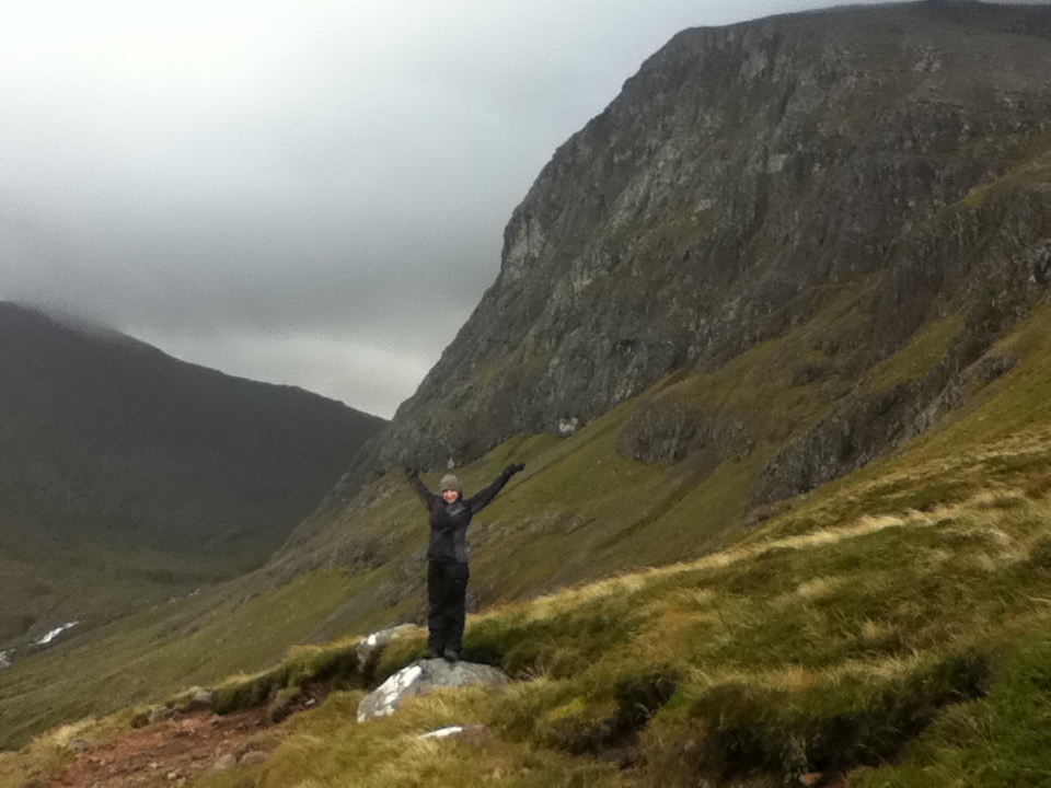    It was a good hike. All told we were out there for a good 6 or 7 hours and (including the road walking to get to the mountain from town and back) we did about 15 miles. The Thia food that night never tasted better! ____________________________________________________________________________________ The next day we headed for Inverness, which is up the loch from Fort William. With the 22 mile Caledonian Canal lock and dam system connecting the water way of Lock Lennhe with Lock Ness, we were able to follow the route that has been used to cross this inhospitable landscape. Of course, the story of the canal could be a blog all it's own too. Below is a link to the site and some images of it. Neptune's Staircase: a series of locks leading form Lennhe to Ness.   Of course, there is the whole Loch Ness Monster business. A bunch of rubbish I say. The loch, itself is the story here. Below is a bit of Wikipiedia for you: Loch Ness is the second largest Scottish loch by surface area at 56.4 km2 (21.8 sq mi) after Loch Lomond, but due to its great depth, it is the largest by volume. Its deepest point is 230 m (755 ft). It contains more fresh water than all the lakes in England and Wales combined, and is the largest body of water on the Great Glen Fault, which runs from Inverness in the north to Fort William in the south. 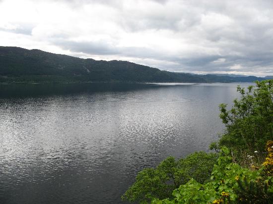 It is a very sweet "loch." Along the way, trying to not get sick on the weaving, heaving bus ride along the narrow winding road north, we pass by a number of crofting villages. Yes, "crofting" - this is the word used to describe small subsistence type farming operations where the land is owned by someone other than the person doing the farming. We might call it "share-cropping" in the states. There is a long tradition of this lifestyle in the Highlands that goes back to the clan days, then into the kings, queens, dukes, and earls, and it continues today. Currently, most crofters need to supplement their income by having another job and many add tourism to their mix to help keep the animals in hay. Just side-tracking briefly, there was an instance in history called "The Clearances" See: http://www.ltscotland.org.uk/scotlandshistory/jacobitesenlightenment In the late 18th century well into the 19th century, Highland estates moved from arable and mixed farming, which supported a large tenant population, to the more profitable sheep-farming. Surplus tenants were ‘cleared’ off the estates from about 1780; and the Clearances were ongoing nearly 70 years later at the time of the potato famine in 1846. Yep, sheep being a viable "crop" changed a lot in the highlands, including the ground cover and forest. There have been historic acts of legislation concerning crofting, starting with the 1886 act that took place after the "clearances" and later, in 1976 legislation was passed to help tenants purchase the land they were working. Lately, in 1993 and as recent as 2010, more attention has been paid to how farming is handled in the highlands and elsewhere in Great Britain. Continuing north to Inverness, we reach this city at the mouth of the River Ness that has long been a seat of power and culture in the highlands.  Of all the cities we have been to in Scotland, this one might be my favorite. I can't say exactly why though. It's a big 'town' vs. a true city, and it is the gateway to much of the highlands and to outer islands such as the Orkney's and the Shetland islands. It just had a real nice feel to it, and it's got a great river running through the middle of it with nice bridges and walkways all along it. It also boasts a very important and busy harbor for sea-going vessels.    This city has a stronger Norse influenced history than others to the south, which adds to its long list of interesting stories. One story that I will share has to do with the local castle (every city has one, right?). This castle is pretty new, rebuilt in 1847, because the original had been blown up during the Jacobite uprisings. The site has had some sort of fortification on it, either wood or stone, since the 11th century. What is the Jacobite uprising you ask? Well, there is a website for that too. It is a fascinating event to me because it represents one of the last times that the Scottish Highland people took up arms against the English. What is most interesting to me is that it took place at a time when most of the men and families involved were educated, and in general, relatively well off people, who took up arms and fought in battles like the Battle of Culloden. Inspired by thier leader "Bonnie Prince Charlie," the brave Highlanders stood across the moor from the Duke of Cumberland and British soldiers before what would be the last full-scale battle to be fought on British soil and the culmianation of the last Jacobite Rising. Like an hour-glass, this battle is the skinny little bit that each grain of sand falls through. The events leading to this battle are the big part above, and the repercussions of the battle and its aftermath being the big part below. The battle of Culloden was one of the defining moments in Scottish Highland history that is still referred to often because of it's disastrous results. We went to the windy plain of Drummossie Moor, just five miles east of town, on a bus to check it out. It was here on 16 April 1746 that found on one side the Jacobite army, determined to reclaim the thrones of Britain and Ireland for its Stuart kin, and on the other was the British army determined to stop its opponents. I will simply write here that the Jacobites, who had often been successful waging a guerilla type campaign agaisnt the British troops, did not fare well in the open battle field where they were out-numbered and out-gunned. It was kind of like when Butch Cassidy and The Sundance Kid came out of that little Mexican villa with guns trained on them from all over, but they went out anyway. Across the wet field, the clansmen charged, right into the teeth of the British guns and cannons. They could not break the government lines. Markers now dot the field approaching what had been the British line, showing how far various clan leaders had gotten in their brave, but ultimately futile, charge. A recreated stone wall has been built where a wall had played a role on the battle.        It is a somber place with a fascinating history that any country's people who have stood up for freedom can relate to. If you're interested in more: Right, so we had a pint at the "oldest pub in Inverness" that night and heard some great music. No pictures of that - too touristy. _________________________________________________ Upon waking the next day, and wanting to get a taste of the North Sea, we took a short train ride up to Narin. Again, this is a town where the River Narin runs into the sea - a common reason for a town up here. However, we came to this one because there is a vast beach that reaches for miles along the northeast corner of the main body of Scotland - looking out into the ever-widening Firth of Moray that leads out to the big water, and over to Norway. (have you got that map out?) We had to be careful not to get "stranded" on an island of sand vs. being on the main land, as the tides and waves change this tidal beach continually. As always, there was a dynamic, beautiful sky to walk under.    We walked the sand for hours and saw no end in sight. Our legs were thankful for the flat ground after all the ascending and decending of the day before, but eventually, we simply turned around, deciding it would be prudent to get back to Narin in time to get tea and cake before catching the train back to Inverness. The next day we took the train back down out of the Highlands through a different route, further east, along the Grampaign Mountains, which is a high, mostly treeless area that stretches from Loch Ness over to Aberdeen.  Stock photo from the Park Service Stark and stunning, not much happens in the way of industry here except for fully equipted hikers and a lot of sheep, and back into Edinburgh via Perth vs. going back down through Glasgow. You don't have a map, do you. Here you go (thank-you graphic maps.com):  ________________________________________________________________________________ Later, on a seperate week-end, we got back on the train from Edinburgh, passed through Glasgow, up and over the passes to Fort William below Ben Nevis and coninued west and north out to Mallig to catch a ferry toward the Inner Hebrides and the Isle of Skye. The west of Scotland, like Ireland, has much of the classic ocean cliff scenery due to the Atlantic ocean grinding away at it for all these millions of years. Everyone has told us, "You must get out to the Western Isles" so off we went. One point of interest that gets the folks on the train excited is going over a bridge that was in a scence of the Harry Potter movie. I took a pic out the widow of the train too. What the heck. It is one of the most beautiful train rides in Scotland according to many. Often people will simply take the train up to Mallig and back for the day just to see the stunningly picturesqe landscape.   Okay, it's pretty, we get it. I know. Anyway, we arrived in Mallig, a nice little port town...(There's Denise!)   ..and booked our passage on the ferry...  ...and headed over to the Isle of Skye...  ...to catch the evening bus that would take us up to Portree..   ... just at sunset, where we would spend the next two days. Skye is a fascinating place with a long history of inhabitaion. However, the Clearances laid a heavy toll on the island when the population went from 20,000 to 9,000. Currently it is doing well with a slight increase in the last census, making it on tourism, fishing, and lumber. It is a big island being rougly 50 miles long and 25 miles wide. The connection of the island to the mainland at the Kyle of Loch Alsh isthumus has lead some to say that it is no longer an island, but I would say it still very much has the flavor and pace of an island. Learn more about it at: On the first day we ran to just catch the bus going around the island to The Culliens. The bus would be going around the peninsula, up past Uig, and was scenic in and of itself. The bus driver knew of the place where I wanted to start the hike and would let me know when we got there. He seemed to know everyone who got on and off, and crofters would wave from the fields and patrures as the bus went by. At what seemed to me to be a random spot in the road, he said, "This is you then!" and getting off, looking up, and then back at the bus pulling away, I told Denise, "Yea, this should work." and sent her up the hill, hoping...  I will just say that is was a pretty awesome hike that we took a few chances on, but it all worked out for a great day. Denise is a trooper to follow me on half-planned routes and infamous "short-cuts" mid-hike. We always make it back, but there is sometimes a "re-orienting" of the original plan. The ridege that we are on looks out to the Western Hibrides, which we will have to get out to another time. It was pretty clear, but we couldn't see up to Stonroway, which is on the island of Lewis, which is only visible on the clearest of days. (This according to the Island resident I was pumping for information on the bus ride earlier - she has a daughter who moved there with her new husband, and she, the mother, is not looking forward to going way out there for the holidays. "Could be stuck out there for days if the weather turns!") The following are pictures going up, at the top, then coming back down, and the last, from the bus stop (about 10 miles from the first bus stop) to get back to Portree.          It was one of the most beautiful hikes we've ever been on - and we have done a fair few. It is an incredibly unique landscape - we tried to compare to Alaska and New Foundland, but that doesn't quite do it either. I would suggest you come yourself to check it out. The next day, we were trying to figure out the buses to do what we wanted to do - keeping in mind that we would need to catch a bus, to catch the ferry, to catch the train back the next day by 10:10 am. It turns out that the winter bus schedule is on and there would be no bus to get us to the ferry on time, so our next best bet was to "hire a car" for 35 pounds, and the company would pick it up at the ferry terminal. "Just leave the keys above the visor and don't lock it," they said. Sweet, old school island stuff - and we're off!  First, Eileen Donan - this castle is home to the Clan McRae, the literature for which, includes my own sir name, McRaith, as a variant spelling of the same clan. The castle itself is a reconstruction of the original, as the original was also blown to bits in 1719 during the Jacobite uprisings. Here it a bit about the blowing up part - everyone's favorite: In 1719 the castle was garrisoned by 46 Spanish soldiers who were supporting the Jacobites. They had established a magazine of gunpowder, and were awaiting the delivery of weapons and cannon from Spain. The English Government caught wind of the intended uprising and sent three heavily armed frigates The Flamborough, The Worcester, and The Enterprise to quell matters. The bombardment of the castle lasted three days, though met with limited success due to the enormity of the castle walls, which in some places are up to 14 feet thick. Finally, Captain Herdman of The Enterprise sent his men ashore and over-whelmed the Spanish defenders. Following the surrender, the government troops discovered the magazine of 343 barrels of gunpowder which was then used to blow up what had remained from the bombardment… Bummer! However, this brief account shows a little bit about how the Jacobite uprising was a part of wider European stuggles for power during that period. (As you may have already learned by following the link earlier) Thankfully, the family decided to re-build it. One Lutenient John McRae-Gilstrap, oversaw the reconstruction project in the 1911 using the original plans. Today, it is both an attraction for visitors in the summer months and is used as a hunting lodge and for other family gatherings by the McRae-Gilstrap family. For 5 pounds I got a closer look.        It has been seen in movies, such as The Highlander. It is a pretty cool castle, and I am working on getting back into the clan for some of those family events. There is more if you like at: In the afternoon, following a small track off the main road not far from the castle, we made our way to the town of Plokton - "The Jewel of the Highlands." Denise had gotten a tip from a lady on a bus in Edinburgh a week or so earlier, when Denise mentioned that we were planning to go up to the Highlands for a couple of days, she said, "Well, you must get to Plockton!" We are now very glad she said so. It is one of the most beautiful and unique little places we have ever been to. It is very well protected from the elements, being tucked back away from the ocean within a little valley behind some larger hills. One can see why people have chosen this spot as home since the stone ages. Bonus! there happened to be a flurry of rainbows amid the intermitant outbursts of rain and sun - then rain, then sun, which = rainbows. Also, palm trees grow there?!        It is a magic little place that made for a great afternoon of exploring. We headed back to Portree for the eveing, so as not to drive in the dark. There are free ranging sheep and cattle all over the island, and being on the "correct side" of the road was challening enough. The next morning we made it to the ferry and caught yet another rain bow as we left the Island of Skye.    By car, boat, train, and bus, we made it back to Dalkeith House around mid-night, having left the hotel at 7:00am. The travel is part of the fun though, and I would do it again in a heartbeat. This then, has been my taste of the Highlands. There, of course, is much more to it than can be described in these few pages - but I hope that you will find it as intreaguing as I do, and will search out more information about your favorites parts. Or perhaps, plan your own trip here for yourself one day. I'll join you, and we can go for a hike! If everything goes just right, we'll end up sitting and doing cross-word puzzles while waiting for a bus at a crazy little rual bus stop with old chairs and wet feet !  |